
We set off for Swedish Lapland at the end of August 2025, with the plan to combine two beautiful rivers, Vistasälven and Kaitumläven, into a logical packrafting route.
You can find the travel article here.
This detailed account serves as a sort of guide for those who would like to follow in our footsteps.
What does it involve?
The total distance is approximately 250 km, of which 90 km is on foot with everything you need on your back (which can weigh over 30 kg). The rest is along the Vistasälven (approx. 35–40 km depending on the water level) and Kaitumälven rivers (110 km).
How to get there?
You need to get to Abisko, where the famous Kungsleden trail begins. We flew to Stockholm and then took a night train via Boden to Abisko. This way, the journey took us about 27 hours, which is not great if you don't have endless time.
Consider flying via Stockholm to Kiruna (from there it's about two hours by train), Luleå (about 6 hours by train), or Narvik to Norway (less than 2 hours). It's faster and cheaper – but sometimes it's better to take the longer and more expensive route because they have Budvar beer in the dining car :).
Our railway specialists, colleagues Bluebell and Piskyn, even traveled by train directly from Prague.
How much time for that?
I absolutely recommend taking as much time as you can to explore. It is so beautiful there that the expedition does not deserve any rushing.
We were on the road from Abisko to Lappeausando (the end of the trip) for 15 days, and with the trip to Sweden and back, it took us about 18 days of traveling.
With this schedule, we didn't have to rush anywhere. We walked a maximum of 20 km per day and covered a similar distance of 20–30 km on the water. Slow mornings, early evenings, time for fishing, camping, swimming, and so on. We even earned ourselves a day off in Nikkaluotka.
Escape point
There is only one escape route from the trip, in the village of Nikkaluokta, which you will reach by boat on the Vist. This is on approximately the 5th or 6th day of the trip. There is a bus service from here to Kiruna.
Similarly, if you have less time, you can just go to Vista, or conversely, take a bus from Kiruna and spend two days in Kaitum before setting off from there.
The last option is to get to Kaitum by helicopter or seaplane, which will drop you off at the top of the lakes. This is done by fishermen or those with bulky and heavy boats. We are not among them, so you may need to Google this option.
What to bring?
So, of course, a packraft with complete whitewater equipment – after all, we have rapids here – WW VI, something for everyone. So, a helmet, a vest, a throw bag, some carabiners and prusiks, and most importantly, a drysuit! I really wouldn't want to do this in a wetsuit. In the end, you'll find that you put on the drysuit when you climb out of the tent and take it off in the evening when you climb back into the tent. Then you don't mind the rain, mosquitoes, nothing... We also had one spare paddle divided into four parts for the six of us.
We didn't bring much clothing. For walking, you definitely need some waterproof items, a jacket, and pants. A few merino undergarments and you're all set.
Shoes are another matter. You can't avoid the swamps, and once your shoes get wet, they won't dry out. Experienced hikers wear rubber boots. However, we went through it in low hiking boots, some even in light cross-country running shoes. You can survive two days with wet shoes, and then it's time for water shoes. Ideally, they should be sturdy enough to walk, scout, carry, and so on. In my case, shoes from Palm.
Some sandals or slippers would be nice for the evenings. But I forgot them at home.
Then, of course, a tent, sleeping bag, and sleeping pad, ideally something that can handle slightly sub-zero temperatures.
And something for cooking, whatever you like. We cooked on gasoline that we bought in Stockholm.
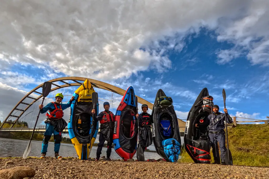
Packrafts
What were we paddling?
- 2 x Eddy bez Tizipu
- 3x Eddy HC s Tizipem
- 1x Voyager s Tizipem
Eddy packrafts with 840D floor and 420D tubes. Voyager 840D/210D.
All with not a minor defect.
In general, I would recommend going with Tizip, because the water is more difficult and the load inside the boat = better handling. However, the guys with their bags on the boat in plastic bags managed everything without any problems even with this setup.
We all had 4-piece Rapa Carbon paddles.
Food and water
Food is a problem. It weighs a ton and doesn't fill you up. You can buy supplies in Nikkaluotka along the way, but they don't have a very large selection. You can also find something at the cottages along the way, if they aren't closed.
We set off with a tactic of lightly replenishing our supplies halfway through, but even so, there was plenty of food and it was difficult. I go for the classic chicken paprika and the like for a few bucks and porridge for breakfast, while others took a more sophisticated approach with modern dishes. Plus about two cookies a day. And coffee, of course.
Fortunately, water is not an issue. It is available almost everywhere and can be drunk straight from the source without any treatment. I would only avoid small reindeer ponds.
For those who enjoy fishing, Kaitum should be paradise. As non-fishermen, we only caught two fish, but it would certainly be possible to catch more. We bought permits for Kaitum and Vista for around SEK 250 per river.
When to go?
We set off on August 29, 2025, exactly on time. That was the end of summer. The reason was simple – mosquitoes. Personally, I prefer to travel north when there is less risk of billions of mosquitoes. The end of summer, when it should be cooler, is ideal. We didn't have cooler weather, but even so, there were about as many mosquitoes as when I go blueberry picking in the forest in summer, which is absolutely none. So, it was fine.
However, I can imagine that if you get it wrong, it won't be a walk in the park, especially in those swamps along the way. Insect repellent and a mosquito net are essential equipment in these parts.
Otherwise, there is less water and fewer mosquitoes in the fall, and it is colder, while in the spring there is more water and the mosquitoes begin to thaw, plus there may be snow at the top. In the summer, there are a million people on the Kungsleden, lots of mosquitoes, and it is hot. So, it depends on how much you love winter and insects...
Water levels
River water levels in Sweden can be found here: Hydrologiskt nuläge | SMHI – Vattenwebb
You need to click on the map and find the point you need to know.
Unfortunately, I can't find the water level during our trip. I only remember that we last checked the website on our phone and concluded that there wasn't much water... :)
Maps
Abisko - Kaitum
Maps for download
Další odkazy
Let´s go
Day 1
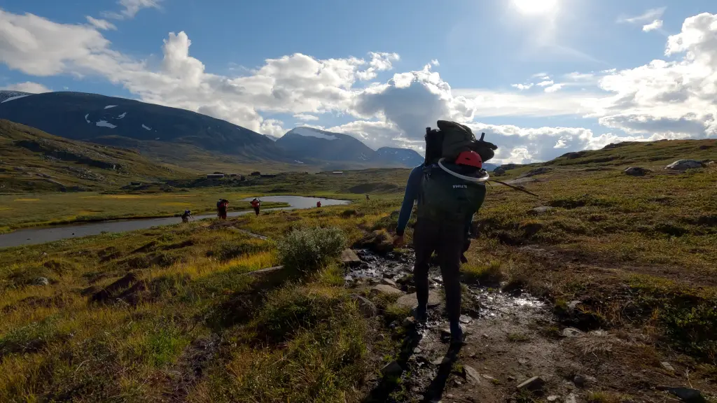
From Abisko Tourist Station, you will set off directly into the Lapland wilderness, which is not so wild after all, as you will spend at least two days on the Kungsleden Trail – the famous royal trail full of hikers of all kinds. There are Americans, Japanese, Czechs, and basically everyone else. If you want to avoid them, I recommend setting off around September 10, as the huts along the trail close around that date and people disappear.
The first steps lead through Abisko National Park, where you can camp at two designated sites. The first is just three kilometers into the hike, behind the bridge over the Nissonjohkka stream. There is a designated area for tents (Nissonjokk), a fire pit, wood, and so on. Since our train arrived in Abisko around 5 p.m., this was our first place to stay for the night.

Day 2
The trail continues along the lakes towards the Abiskojaure hut, where it turns left and begins to climb. After a few kilometers, you will reach the border of the National Park and can happily start camping wherever you like. If you arrive in Abisko in the morning on the first day, it is about 17 km to here, so nothing you can't walk.
For Alpine wolves, this is not a particularly difficult climb, just over 300 meters in altitude. But with a 30-kilogram backpack, it will test your strength, no doubt about it. The good news is that this is the biggest climb of the first part of the trip.
Our plan for the second day was to reach the lakes on the other side of the ridge, but by evening, after walking about 20 km, we had had enough and gratefully accepted a reasonable spot above the lakes by a second stream springing a short distance below Mount Ribakbákti. We were rewarded with our first reindeer and a beautiful sunset.

Day 3
Beautiful weather and a pilgrimage around a series of lakes ending at Lake Alisjávri. We hesitated for a moment whether to paddle across the lakes on packrafts, but there was a headwind, so we ended up walking. The lakes are also connected by the flowing Alesjokk River, and these passages would have to be carried.
Once you descend to the lakes, you will find a boat dock where, until the end of August, pilgrims can take a boat across Lake Alisjávri to the Alesjaure cabin. This is an option for the lazy. We were there on September 1, so we did not have the pleasure.
The journey around the lakes is beautiful and passes quickly. Even so, we ended up spending the day at the Alesjávri cottage. We had covered just over 10 km and didn't feel like going any further. There are several options to choose from. Either you pitch your tents behind the bridge opposite the cottage and don't want anything, in which case you don't pay anything. Or you pitch your tents and use the sauna and kitchen. Then it costs 300 SEK. Or you can stay in the cottage for 600 SEK.
Half of our tour group chose the 300 SEK option and half chose the 600 SEK option. The reason was, of course, the sauna, which in these areas is always an interesting cross-section of nationalities, personalities, and political beliefs. All topped off with a jump into the icy river. Awesome.
Day 4
You will mark this day in your calendar in gold letters. That's because you will see the river of your dreams for the first time. And maybe you'll even take a ride on it. Finally.
In the morning, you finally leave Kungsleden, which means only one thing—people disappear. On the way to Vist, we met about three poor souls, but compared to previous days, it's nothing.
The route first leads back along the lake towards the Lappish village of Alisjávri, which looks like the backdrop of the village of Alisjávri. Just before the village, however, the trail climbs to the pass to the Čazajávri lakes. A little over 100 meters of elevation gain and you are where you wanted to be. The dream river Vistasälven flows out of the large and small Čazajávri lakes. It will only be a moment before it becomes packraftable.
The breathtakingly beautiful Vistas Valley begins to unfold before your eyes. It looks like something out of Lord of the Rings. The trail slowly descends past an even more beautiful waterfall cascading from a stream that originates high up on the glacier. Yes, you see, glaciers are everywhere. The mountains here reach heights of up to two thousand meters.
You keep going, hoping that the water will rise, because your backpacks are extremely heavy. You need to be smart here, because deeper water alternates with shallow rocky areas. Even when the water level is lower, it should almost always be possible at the confluence of the Vista and Unna Vistasaš streams. And that's where we launched our packrafts. It's less than 15 km from the cottage to here.
Now it's up to you. We chose a short trip of about 5 km to the Visstastuga cottage. It's a relaxing stretch of free-flowing river. At one point, we had to walk a few meters through the water because it was really shallow, but otherwise it was easily navigable. A third of the group stayed at the cottage again, while two-thirds slept at the official campsite on the other side of the river for free. The sauna would have been available again, but we arrived quite late, around 7 p.m., and it was already closed.

Day 5
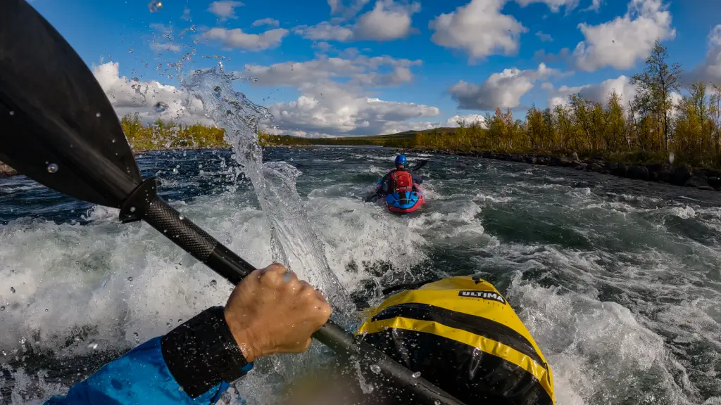
Finally, the river. Below, I will try to describe how we rode Vista under the given water conditions. However, I recommend that you do not blindly follow us and always consider what to do and how to do it on the spot. After all, this is not a guidebook, is it?
We enter the river right at the campsite under the bridge, and it's great fun right from the start. The river twists and turns, so watch out for fallen trees. The river has some gentle rapids and is easy to navigate by eye.
The first problem arises here... Even from a distance, it is clear that this is something bigger, as indicated by the white whorls spinning on the horizon. After inspection, we find the difficulty to be roughly WW III with two rollers, and we first go left and then, ideally, more to the right at the bottom. Very nice.
Another major problem is behind the bridge over the river. I recommend stopping immediately after the S-bend, which ends with a right-hand turn, behind which the bridge appears. Once you drive under the bridge, it's too late. There's a nasty five ahead, which, unlike other fives, really looks like a five. It's very long and even more confusing. And you are at a crossroads. Below this five, the river flows very nicely for another 5 km or so through a section with lots of WW IIIs. Those who don't trust themselves, and many before us have done just that, pack up their boats, cross the bridge, and carry them for those 5 km. However, the path here moves away from the water and only returns to the river after those 5 km – so you can't change your mind halfway through.
If I had to give my opinion, I would say that the transfer is a shame. You miss out on the best part of the whole river. When you get back to the water, there are only a few rapids and pools left.
So we decided to carry our gear across the Class V rapids on the right bank, over stone thresholds and through marshland. We had lunch below the rapids and then pressed on, planning to scout anything suspicious. The good news is that anything suspicious can easily be carried across the bank. However, that didn't happen.
We only got out of the boat twice. The first time was at a suspicious left-hand bend, where the river speeds up into a decent roller, and the second time was at the end of the whole passage, where there is a long, beautiful WW III. The rest went by quickly with no visible dangerous spots. In the first case, the ideal line was on the left bank (also easy to carry). In the second case, first in the middle and then on the right. Carrying through the forest is probably possible if needed.
The good news is that the river offers quite a few eddies and places along the shore where you can rest if you are swimming. The water is usually waist-deep at most.
Below the last rapids, the river slows down and flows less and less until it almost stops flowing altogether.
Since the weather wasn't great and it was raining lightly, we anchored around four o'clock somewhere in the birch trees on the right bank and set up camp. Piskin and Bluebell, who were rushing to catch the bus to Nikkalukta, continued on and eventually even took a river taxi. A few bends of the river further on, a guy takes tourists the last ten kilometers of the deep, stagnant Vista. This may be a tip for those who don't like paddling.

Day 6
On the sixth day, you can look forward to endless paddling down a beautiful river. We had 15 km to go to reach our destination. With a few stops, it took us about 5 hours. If you're feeling lazy, you can try a boat – you can even find the mooring on Mapy.cz.
In Nikkalutka, you will find a wonderful tourist center with a great pub. You can stay in cabins or tents. There is a kitchen, showers, and so on.
At the same time, this will be the last encounter with any civilization for the rest of the trip. I therefore recommend purchasing whatever you deem appropriate.

Day 7
Since we had plenty of time, we took a day off. We dried some things, rearranged, bought some more stuff, and so on.
I highly recommend having breakfast at the pub for about 200 SEK. After a week of porridge, it was a great change. I sat there from 8 to 10 and ate everything.
Beer for an outrageous 120 SEK is undrinkable. A can for about 50 SEK is also undrinkable, I think. The only bread available for the journey is frozen.

Day 8
A day marked by a difficult hike towards the Kaitum River. Before leaving, I recommend weighing your backpack on the hanging scale in front of the tourist center. After replenishing my supplies, mine weighed 33.5 kg.
If your shoes have been dry until now, you can count yourself lucky. Today marks the end of the dry spell. Just beyond the village, you will enter a meadow full of water, and that's it.
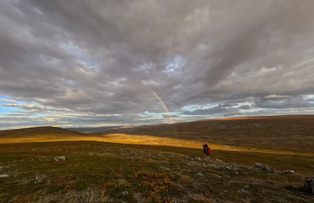
Today's plan was to reach a small rescue hut located about 20 kilometers into the hike. First, you walk through a beautiful forest along a lake for about 5 km, and then you climb a brutal slope straight up until the trees disappear. You enter a wasteland of all wastelands, interrupted only by a bridge over a stream halfway through the stage. Immediately after the bridge, you encounter real swamps. The wood is rotten and doesn't hold. Your shoes are no longer dry, but that doesn't matter.
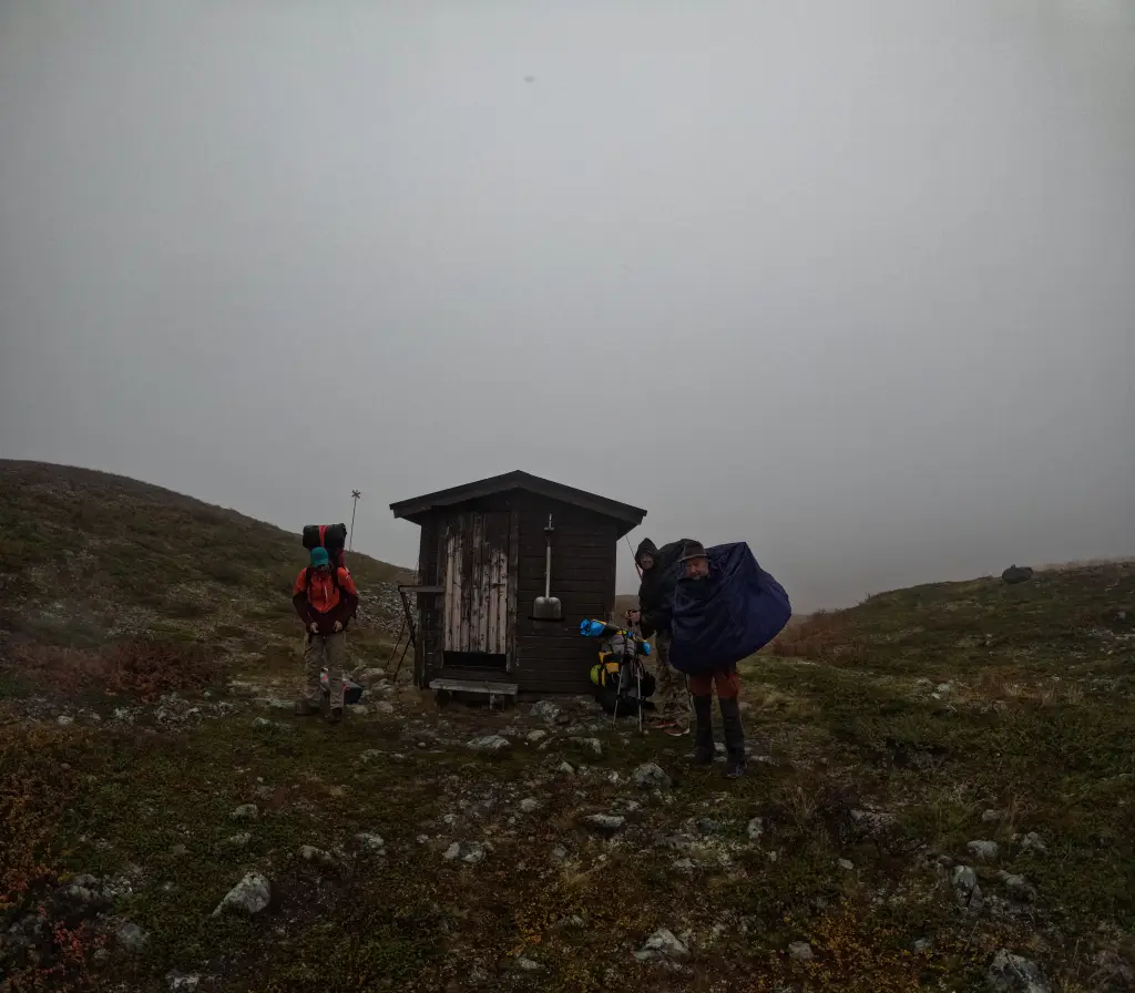
Behind the marshes, we climb uphill for a while to another plateau where dozens of reindeer graze, then a little further beyond the ridge, and we can already see the cabin in the valley. Since it is supposed to rain at night, the four of us squeeze into the cabin. Otherwise, there is only a table and two benches, a rescue box, and an outhouse outside.
The journey through this stage took us the whole day. We could have gone further, but it would have been too much.
Day 9
Today, we have a shorter half of the crossing to the Kaitum River ahead of us. First, there is a bit of an uphill climb to the highest point of the trip (950 m), but then you will see Kaitum below you. It is about 12 km to the river and the Tjuonajakk fishing camp. This is the last bit of civilization, but in our case, it is abandoned. In the summer, you can rent a cabin here and go fishing, but in September it is already closed.
It's raining and we don't feel like pitching our tents. However, Lukáš finds one cabin open, apparently for emergencies. It's full of mouse droppings, but so what. It's a great place for tired packrafters to rest. Otherwise, it's the very first cabin to the right of the gate – buried in the ground, just in case...
The crossing took us about 3.5 hours today.
Today also marks the end of the walking part of the expedition. From here on, it's all downriver. You have about 110 km ahead of you on the unregulated Kaitumälven River, and there's plenty to look forward to.
Day 10
The Kaitum flows very slowly at first, or rather not at all. Most of the day will be spent paddling, with the occasional gentle ride over a small rapid.
A short distance after leaving the fishing village, you will reach KM 110 measured from the destination in Lappeasuando. That is the distance that lies ahead of you. You haven't lost much by going upstream, unless you enjoy endless paddling on lakes. There are 40 km of those upstream.
There are essentially only two complications on the way downstream.
The first is the beautiful Liettikkuikka rapids, marked as WW IV. It starts where the river narrows and where you can see a cottage on the left bank. With our water level, it's more like a three. We scout comfortably on the rocks to the right. There are fairly large waves here, but otherwise it doesn't look too bad. So we go straight down the current and stop in the eddy near the bank below the first part. The rest of the rapids slowly lose their strength until they end. We didn't see any major hazards anywhere.
On the map, you will also find sections marked as WW II and a long WW III. It is a beautiful, brisk ride, again without any major problems.
The ideal place to end the day is at approximately KM 92, after a twenty-kilometer trip, at the Stuor Kärtje rapids. You can hear them from far away, and the trees on the horizon are noticeably lower, so you can't miss them. We climb out on the left bank before the rapids, straight onto a well-trodden path, where there is a fireplace and a few places to pitch tents. A wonderful place to spend the night.
The rapids themselves look quite navigable at the top, but in the lower section they rush over vertical thresholds. On the left bank there is a large slide ending in a brutal roller. So we definitely won't be going there.
Day 11
From the campfire site along the trail, you can easily carry your boat to the mini beach below the rapids and hop in the water. It's a beautiful WW III and WW II ride for about 4 km to the Unna Kärtje rapids. We prefer to stop more to the left above the rapids, but you can also stop just above the rapids in the eddy on the right and then carry your boat a short distance. After scouting, we find that it's more like a class III if we take the line along the left bank, so we go for it. A beautiful long rapid without losing a flower.
This is followed by a long, officially marked WW IV, so some of those ahead of us carried their boats all the way to the bridge over the left tributary of the river. We paddle along without any problems, no tricky spots, just a beautiful river flowing briskly.
Kaitum slowly begins to lose strength, with the occasional longer paddle, but otherwise it slowly rushes forward. Between KM 77 and 75, there is a longer WW III marked, but with our water level, it is more like a class II, which we navigate without any problems.
The campsite comes again after about 20 km of wandering in a left-hand bend before the WW I passage. On the right side in front of you, you will see an unusual higher rocky bank (otherwise, there is mostly only a low bank with a birch forest around). A visible footpath leads from the water, and at the top you will find three fire pits, flat areas for tents, and a beautiful view of the river. The nearest civilization is 15 km down the river, so it's hard to say who comes here. In the quiet above the rapids, we finally catch a grayling and a pike. A beautiful place to spend the night.

Day 12
It is about 15 km to civilization, which is the settlement of Katium. There are a few easy rapids on the way, as well as a longer triple rapid, which is more like WW II–III, a wide, beautiful rapid. Otherwise, up to the railway bridge, it is more like sailing than paddling, which we did not expect at all.
The village of Kaitum is another possible place to retreat to. There is a train station here, but we couldn't find a train that would stop here, so we planned to continue on when planning the expedition. It would be a shame to end here, because the river further on is really worth seeing.
We don't even get off here and head towards Killinge, which is a real gem on shallow lakes. It takes us about 2 hours to cover some 8 km.
From Killinge onwards, the river no longer flows through wilderness, but here and there you will see cottages and signs of civilization. In addition, a road connecting Killinge and Skaulo runs along the right bank of the river. Ultimately, this section could be traveled solo and would still be worthwhile.
Below Killinge lurks a terrifying waterfall followed by approximately 4 km of rapids marked as WW IV – V. Some people deal with this whole escapade by throwing their boat on their backs at Killinge and first carrying it along the road and then along the right bank for the entire stretch.
We decided to set off along the river and carry our boats if necessary, because so far it had always been possible to carry them across the river somehow.
You can hear Killingilinkka WW VI from afar, and it is easy to stop on the left bank. There are several footpaths leading to it, as the place seems to be popular. Above the rapids, you will find a classic Scandinavian tourist hut open to everyone and a place for tents next to it. It is an ideal place to spend the night. After all, the sunset over the rapids is worth seeing.
Otherwise, we obviously won't be going for the six grade rapid. Maybe at the top, but at the bottom there's a final ultra-slide into a mega-wave, which salmon jump against the current.

Day 13
Perhaps the most beautiful day on the river during the entire trip.
The boats go into the water just below the rapids, from the tents down the path. The same path is used to scout a large part of the river downstream, which is reported in the morning briefing as looking OK.
Right after getting in, things move quickly and the first problem is visible from afar. We scout the right side again – it's a relatively long rapid with several steps. We choose the left line and sail through beautifully once again.
A little further on, there is another rapid on the wide river, where we only carry the first level for about 20 meters along the left bank. Lukáš ends up going all the way. The individual levels in the rapid and the rollers behind them will probably be tough when the water is higher. But with our water level, it's no problem.
The last problem comes in a right-hand bend, where the river narrows and picks up speed. We scout the rocks on the right and then ride straight through the clearly visible current in the middle. It's probably a good idea to hit it here, because outside the current it doesn't look so friendly. At the end of the rapids, there are two larger waves and eddy on the left. And that's it.
This fun lasted three hours, including scouting, filming, planned guard duty with slingshots (we always went in pairs), and so on.
Then there are some WW II and WW III and one short four officially marked. In any case, everything is at least one grade lower, and we're going by eye.
If we spent three hours here, the next 10 km of the river will take us about 45 minutes. There is a beautiful flowing river marked as WW I – II. A gentle, endless rapids, something like the Vltava River below Dívčák, 10 km long.
The map shows two open huts on the right bank, and we find refuge in the second one. There are 31 km left to our destination.

Day 14
If you want, you can easily get home today. But we have plenty of time and are in no hurry.
At the beginning of the day, the river flows like yesterday, then a little more (WW III, more like II), and then it stops flowing altogether at the lake passage near the Neitisuanto settlement on the right bank. It's about 5 km of paddling against the wind and waves.
The good news, however, is that from the end of the lake it flows almost continuously to the finish line.
In the rain, relatively early in the afternoon, we are grateful for a fully equipped fishing shelter on the left bank of the river, some 10 km before our destination.

Day 15
Here we are. The last day. The water is still flowing beautifully to the confluence of the Kalixälven and Kaitumälven rivers. Here is the last 2 km long lake and a road bridge. Behind it, on the left, we finally get out of the water.
There is a road connecting Kiruna and Gälivare and a rest area with accommodation. To catch the bus, you have to walk 5 km along the road to the Puoltikasvaara stop. During the week, there is an excellent bakery here. When it is closed, there is at least a vending machine.
The closest bus to Gällivare leaves the next morning. But halfway to the bus stop, we hitch a ride with an Italian geologist and speed back to civilization.
Other articles from our blog
Practical advices for every packrafter

Co s sebou na packraftové expedice, abyste dopluli do cíle, i když packraft rozsápe medvěd? A co nechat doma, když jedete jen na pivo na Vltavu?

Not sure whether to go with a packraft or a kayak? Need to decide which one is right for you? Want to improve your packrafting skills? Want to spend a weekend with a group of packrafting enthusiasts and join them on a classic overnight packrafting trip to a campfire on the Vltava River? Then the PACKRAFT SUMMER MEETUP is the perfect event for you.
Not sure whether to choose a packraft or a kayak? Need to decide which one is right for you? Then this event is for you. What to expect: All Ultima packraft models, including this year’s new releases—the Voyager and Snape bow bags, dry bags, and other packraft accessories—as well as RobFin packrafts. You’ll also have the chance to try out battery-powered pumps.


